


WM 202206.12.2022
Routenbeschreibung
Rigi Hochflue (1699m)
WM 2022
Rigi-Hochflue North Face
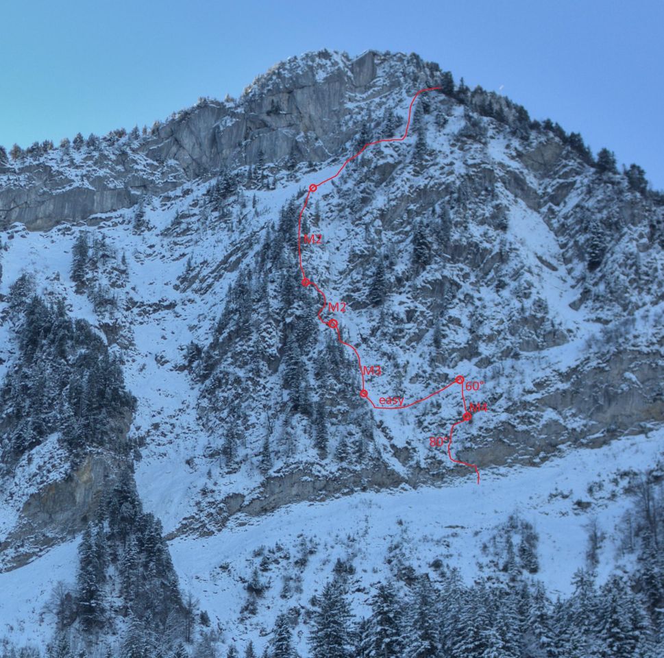
“WM 2022”, M3-4, 80°, 350m
First ascent: 06.12.2022; Franz Friebel, James O'Sullivan
It involves a lot of grass, requires good footwork, is apparently a winter activity and is a stupid idea.
Route: The appeal of this route is the excellent ratio of adventure to accessibility by public transport. The climbing is more of an acquired taste. There are always trees for a solid belay, but the protection of the pitch can be as little as ice piton hammered into grass and slings around twigs. Frozen turf does exist, but a good amount of digging is needed to get there. We followed the easiest line, but climbing the direct couloir is certainly possible.
1: start on the right side of the couloir and go left to the grass field (80°), straight to an obvious snow ledge and right towards a tree.
2: straight up over the short cliff (M4) and follow the 60° grass field.
3: easy 60m traverse into the couloir. The pitches 1,2 and 3 can be cut short by going left a lot earlier. This involves climbing of almost vertical grass an requires good conditions.
4: 30m on the left side of the couloir, M3. Belay on the left before the couloir get more difficult
5: leave toward the left and climb up a 5m slab, traverse right underneath the overhang and continue on the ridge
6: 60m of simul climbing in easy mixed terrain until you reach the snow field. From where you top out to the summit or hiking trail.
The approach and exit snow fields are prone to gliding avalanches. While the critical sections at the lower snow field can be avoided, the upper snow field cannot and is looming over the couloir.
Access: Start at bus stop Lauerz, Dorf and follow the hiking trail towards Gätterlipass. At 1100m turn left and walk towards the face. The last 200 vertical meter walk through the forest directly toward the face
Descent: one of the many hiking trails
Equipment: slings, ice piton, warthogs, hexentrics 0.5-4, nuts, cams 0.3-1
Verhältnisse zu dieser Route
Aktuelle Verhältnisse in der Umgebung
Rigi Kulm (1798m)13.06.2026
Grosser Mythen (1899m)07.06.2026
Uri-Rotstock (2928m)30.05.2026
Grosser Mythen (1899m)30.05.2026
Schartihöreli (1693m)26.05.2026
Verhältnismeldungen auf Partner-Portalen
Tourenberichte von Camptocamp.org
Andere Routen in der Umgebung
Metadaten

Rigi Hochflue (1699m)
WM 2022
Karte