


Monte Albano (Gardaseeberge) (590m)25.09.2022
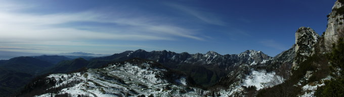
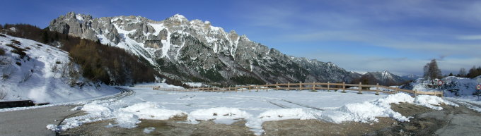
Tourenbeginn um 08:30 Uhr bei 5°C und heiterem Wetter. Von gestern Nacht lag noch 10 cm Neuschnee. Die Ketten hinauf zum Gipfel sind schneefrei. Die Westseite der Bergkette ist noch stark verschneit. Die zugeschneiten Kehren auf hartem Firn hinab zur Selleta dell'Emmele waren ohne Steigeisen etwas heikel.
Der Schanzenweg erinnert etwas an die Strada delle 52 Gallerie durch nördlich gelegenen nahen Pasubio. Und es kommt ein bißchen „Brenta-Feeling“ auf.
Die Tunnel sind kurz, so dass man zum Durchlaufen keine Lampe benötigt. Die Route ist sehr gut beschildert und markiert. Kein Gipfelbuch vorhanden. Wer bringt ein neues mit ?
Bei Tourenbeginn am Passo di Campogrosso startete ein Skitourengeher mit Hund Richtung Monte Obante im Westen. Rifugio Campogrosso war bereits geöffnet. An der Forcella del Cornetto traf ich auf 2 Italiener, welche gerade vom Mte. Cornetto abgestiegen sind und deren Fußspuren im Schnee ich nutzen konnte. Sie stiegen vom Parkplatz am Pasubio-Monument auf und gingen den Sentiero del Sengio Alto in umgekehrter Richtung an. Ursprünglich wollte ich über die Westseite (Klettersteig Nr. 176, Malga Boffetal, Fernwanderweg 05) zurücklaufen. Wegen der Schneemengen dort disponierte ich jedoch um und es entstand die hier beschriebene Route über den Sentiero Peruffo Bruno zurück über die Ostseite.
Letzte Änderung: 20.06.2019, 13:03Aufrufe: 1850 mal angezeigt
Aktuelle Verhältnisse in der Umgebung
Metadaten

Monte Cornetto (1899m)
Sentiero del Sengio Alto (Rif. Campogrosso – Pso. delle Gane – Forc. del Baffelàn – Passo del Bafelàn – Passo degli Onari - Forc. del Cornetteo – Mte. Cornetto – Selletta dell`Emmele – loc. Loffa 1472 – loc. Loffa 1420 – SP 99 – Rif. Campogrosso)
Karte