




Muott‘Ota (2458m)11.10.2026
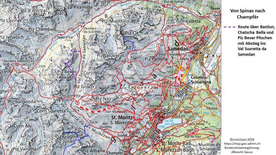
Die Brücke über die Ova da Suvretta bei Plaunins beim P. 2379 m nicht entdeckt. Der Bach kann aber dort passabel überschritten werden. Bachüberschreitung weiter unterhalb zur Zeit schwierig, selbst keine gute Option gesehen. Recht steile Rasenschrofen unterhalb Bastiun. Die N-Flanke hinauf zur Chatscha Bella (2922 m) weist gut gangbare Schrofen und erst im oberen Teil grob blockigeres Gelände auf. Nur ganz ganz kurze Passagen von weichem Restschnee. Auf der Chatscha Bella den P. 2956 m als Piz Bever Pitschen zunächst fehlinterpretiert. Erst auf dem P. 2956 m zeigte sich klar, dass von dort, am besten ostseitig über Felsen (T4, I), in eine Scharte an den N-Fuß des Piz Bever Pitschen abgestiegen werden musste.
Aufstieg im groben Geröll über dessen NNO-Flanke bzw. N-Grat (T3).
Ein Abstieg nach SW in Richtung Piz Bever in eine folgende Scharte war wegen eines dort sehr steil abfallenden Gratabbruchs keine Option. Daher über die NNO-Flanke zurück in die Scharte am N-Fuß des Piz Bever Pitschen. Von dort Abstieg nach O, später SO, z.T. anfangs auf angenehmen Rasenschrofen zwischen Felsabbrüchen hindurch auf das Plateau (ca. 2780 m) oberhalb Grevas da Crasta. Von dort mühsamer die steilen Schrofen Richtung SO absteigend gequert und bei ca. 2680 m Rasenbänder erreicht. Über diese weiter querend und fallend zum markierten Wanderweg Richtung Pass Suvretta, der auf ca. 2540 m Höhe erreicht wurde. Nun hinauf zum Pass Suvretta (2614 m) und auf dem Wanderweg hinunter nach Champfèr (Bushaltestelle Guardalej).
Aufstieg im groben Geröll über dessen NNO-Flanke bzw. N-Grat (T3).
Ein Abstieg nach SW in Richtung Piz Bever in eine folgende Scharte war wegen eines dort sehr steil abfallenden Gratabbruchs keine Option. Daher über die NNO-Flanke zurück in die Scharte am N-Fuß des Piz Bever Pitschen. Von dort Abstieg nach O, später SO, z.T. anfangs auf angenehmen Rasenschrofen zwischen Felsabbrüchen hindurch auf das Plateau (ca. 2780 m) oberhalb Grevas da Crasta. Von dort mühsamer die steilen Schrofen Richtung SO absteigend gequert und bei ca. 2680 m Rasenbänder erreicht. Über diese weiter querend und fallend zum markierten Wanderweg Richtung Pass Suvretta, der auf ca. 2540 m Höhe erreicht wurde. Nun hinauf zum Pass Suvretta (2614 m) und auf dem Wanderweg hinunter nach Champfèr (Bushaltestelle Guardalej).
Die wenigen Schneekontakte werden wahrscheinlich den kommenden Hitzetagen zum Opfer fallen, so dass Gamaschen sich erübrigen.
Letzte Änderung: 24.06.2026, 15:51Aufrufe: 263 mal angezeigt
Aktuelle Verhältnisse in der Umgebung
Metadaten


Piz Bever Pitschen (2976m)
Von Spinas durch das Val Bever in das Val Suvretta da Samedan und über die O-Flanke zur Bastiun, die N-Flanke zur Chatscha Bella und die NNO-Flanke zum Gipfel. Abstieg nach O und über den Pass Suvretta nach Champfèr.
Karte