


Sotaregn (900m)19.07.2026
Tourenbeginn um 08:40 Uhr bei 7°C unter bedecktem Himmel. Der Kamm wie auch die Flanken waren schneefrei. Im Rifugio Lago floss noch Wasser aus dem Hahn. Die versorgende Quelle war noch nicht zugefroren. Der Cheminee in der Hütte sieht zwar gut aus, zieht aber schlecht, wenn der Wind in den Schornstein drückt und spendiert auch nicht viel Wärme, weil der meiste Anteil nach oben verraucht.
Vom 4.-6.10.2024 tags und nachts fand im Nordosten des Tessin der Gravel-Bikepacking Challange Wettbewerb „Dead Ends & Dolci“ statt. Über 500 km und ca. 9000 Hm sollten die Teilnehmer absolvieren. Darum sahen wir heute, wie auch am Folgetag viele Radler unterwegs in dieser einsamen Gegend. Einer der 6 Checkpoints war die Capanna Cava. Jedoch hatte die bewartete Hütte inzwischen geschlossen. Ob wie von Anfang an geplant, oder kurzfristig, weil angeblich das Kind vom Hütten-Pächterpaar krank wurde, sei dahingestellt. Jedenfalls erzählten uns das die 4 jungen Damen, welche mit dem Kleinbus mit Innsbrucker Kennzeichen bis zur Alpe hinaufgefahren waren und den Winterraum beanspruchten, um davor Stellung auf einen der 6 Checkpoints für die 36 Stunden eingerichtet zu halten (Kuchen-Versorgung), ohne nachweislich diesen Raum zuvor gebucht, bzw. reserviert zu haben.
Bei all unserem Respekt vor dieser Challenge, aber hier ein Hinweis an den Veranstalter von Bikepacking.com und die Damen: Es wäre fair, wenn der Veranstalter nicht bloß anonym digital in den Medien und ohne Adresse und Telefonnummer erscheinen würde, um bei Nachfragen (nicht ?) erreichbar zu sein. Und es wäre respektvoll, wenn er wie auch die Checkpoint-Besetzung inzwischen auch digitale Gepflogenheiten bei Berghütten nutzen würden. Und zwar ihre geplante Anwesenheit, bzw. Benutzung im Reservierungsportal der Hütten einzutragen. Denn im vorliegenden Fall: https://www.alpsonline.org/reservation/calendar?hut_id=580&lang=it
hatten wir reserviert für die Übernachtung vom 4. zum 5. Oktober. Gemäß Reservationnummer 4711654 vom 2.10.2024 erhielten wir systembedingt Bestätigung dafür, dass dafür die Selbstversorger-Hütte für 5 Personen noch für 3 Personen zur Benutzung frei war. Ein Blick am 4.10. morgens in den Buchungskalender der Hütte zeigte immer noch 1 freien Lagerplatz an. Dagegen hatten systemlos die 4 Damen an die Tür des Hüttchens ihr selbstgeschriebenes Pappschild „Riservato“ hingehängt und wollten uns nicht reinlassen.
Nun ja, der Klügere gibt nach. Damit gibt er vor, wer der Dümmere ist.
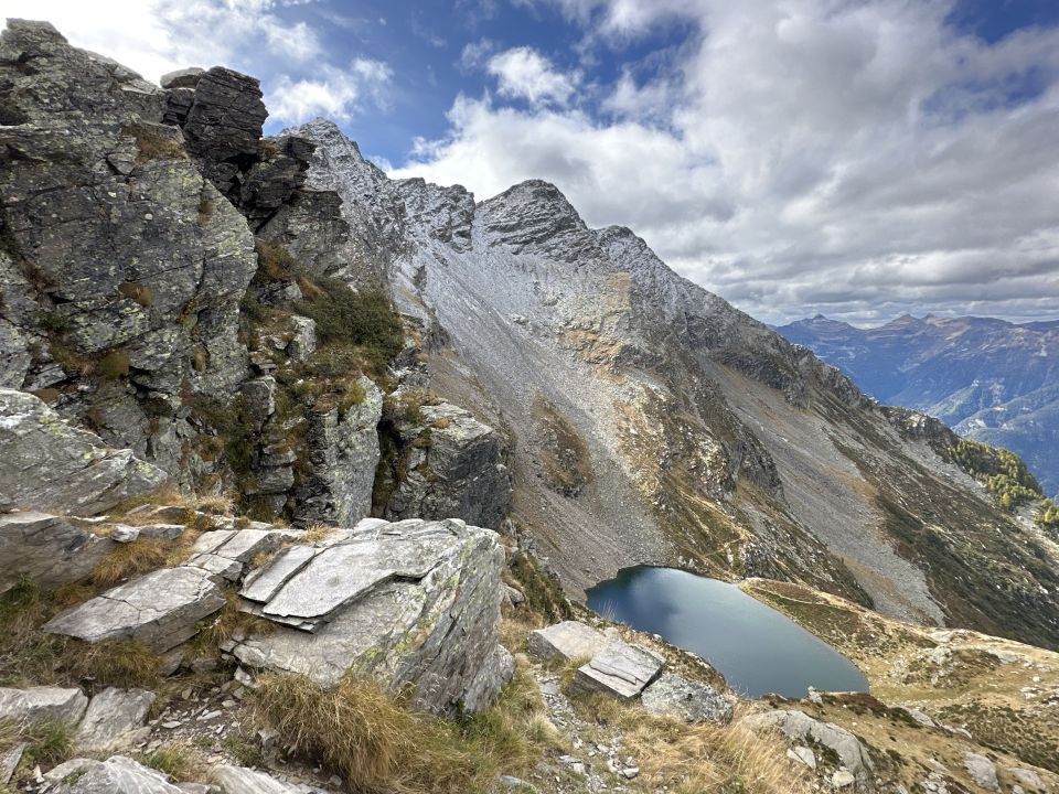
So disponierten wir um. Anstatt über den Passo del Mauro den Torrent Basso anzugehen und abends wieder an der Hütte zu sein, um früh morgens abzusteigen zum Rifugio Giumella, liefen wir zum kleinen Rifugio Lagh und unternahmen die oben geschilderte Tour.
Die idyllisch gelegene Hütte Rifugio Lago, für die wir aus o.g. Grunde nicht vorreserviert hatten, war dennoch frei. Das Wasser lief noch. Weil nicht Frost herrschte. Nur der Kamin verlangte Kunststückchen beim Anzünden ab, weil der Wind von oben in die Mündung des Kamins drückte und Spänchen-Flämmchen schnell ausdrückte.
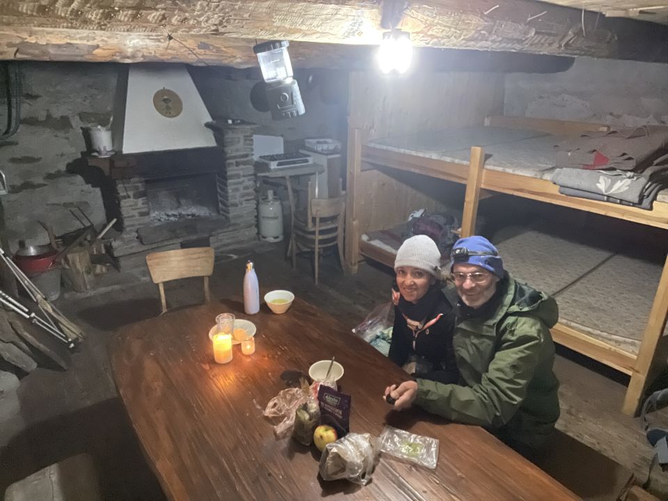
Am frühen Abend kamen dann Fritz und Katarina aus dem Berner Land mit ihrem Zelt an, welches sie windgeschützt hinter der Ruine aufstellten. Sie stiegen gut bepackt von Biasca höhenmeterintensiv auf. Respekt. Irgendwann hatte ich dann den Kamin zum Laufen gebracht. Sie konnten sich danach daran erwärmen zum Abendbrot.
Rifugio Alpe di Lago kostet CHF 15,00 pro Erwachsener, plus Holzverbrauch CHF 5,00. Die Blechkasse des Vertrauens wurde von Idioten aufgebrochen.
Darum überwiesen wir den Obolus an die PostFinance in Bern. Das Hüttenbuch am Rifugio Lago ist am 4.8.2024 begonnen worden und hat noch nicht viele Einträge.
Letzte Änderung: 10.10.2024, 23:32Aufrufe: 699 mal angezeigt
Aktuelle Verhältnisse in der Umgebung
Metadaten

Mottone di Cava (2374m)
Biborgh – Ponte di Cengio – Fontai – Alpe di Sceng – P 1780 – P 1889 – Alpe di Cava – Cap. Cava – Forc. di Lago – Rif. Lagh – S-Rinne - OSO-Grat – Mottone di Cava – Mottone – Forc. di Lago – Rif. Lagh
Karte