


Poncione di Manio (2924m)04.07.2026
Tourenbeginn um 02:40 Uhr bei 14°C unter sternenklarem Himmel. Das Sternenbild der Waage leuchtet um diese Zeit vor einem und gibt die Richtung vor. Den bequemen Weg zur Hütte beleuchtet die Stirnlampe.
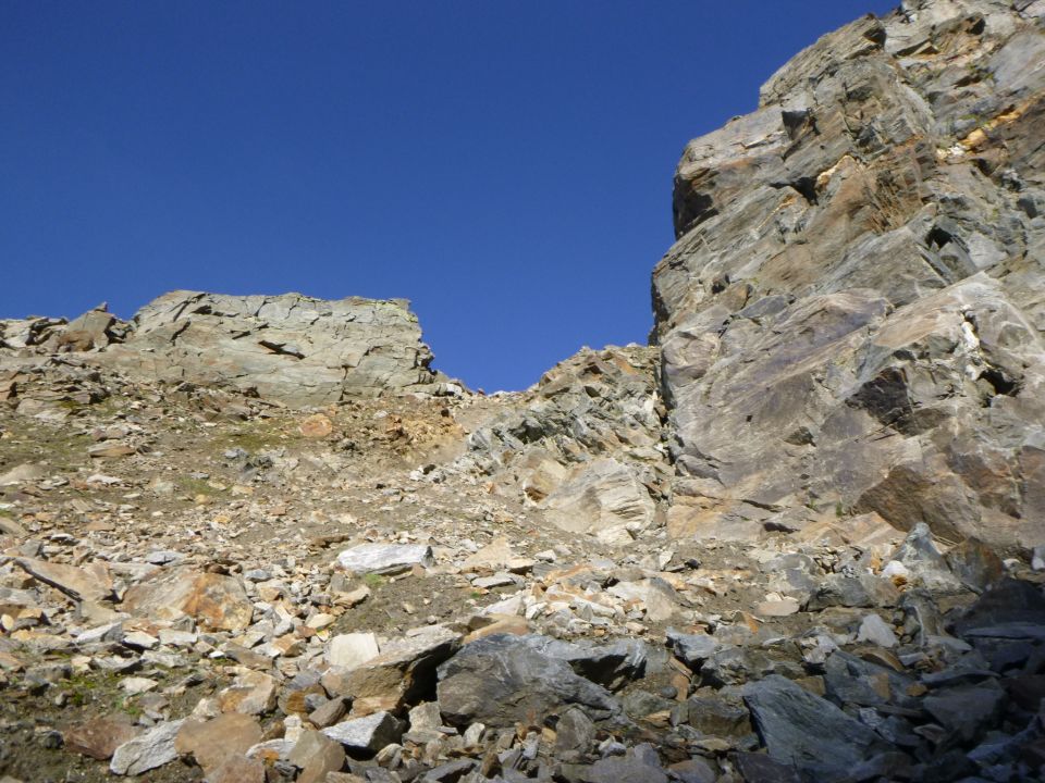
Die wenigen Sommer-Tourenberichte, welche es über die Routen zum / vom Gipfel gibt, sind veraltet. Die 4 betreffenden Gletscher, oder deren Reste, auf die man trifft, sind bereits erheblich abgeschmolzen, so dass die Routen immer mehr weglos über Felsblöcke, oder Geröll verlaufen. Damit stimmen die Zeitangaben von damals nicht mehr mit heutigen notwendigen überein. Insofern ist es im Winter eventuell einfacher möglich, die Scharte und den Pass zu überqueren, sowie vom Gipfel abzusteigen, bzw. abzufahren. Hinzu kommt im Sommer mehr Zeitbedarf zur Findung des geeigneten Durchstiegs. Denn nur in wenigen Passagen unterhalb der Gletscherzone findet man Steinmandl vor, oder auf italienischer Seite gelbe Farbpunkte. Idealerweise kürzt man den Tag ab, entweder in der Binntalhütte des SAC, oder in der (privaten) Mittlenberghütte.
Im Abstieg machte ich den Fehler und versuchte der Winterroute zu folgen (ähnlich Route 801.9 laut SAC-Alpinführer) über den NO-Kamm, also bei Erreichen der NO-Rippe nach links auf nördlichen Sabbione-Gletscher zu gelangen. Die Winterroute führt jedoch mehr oder weniger über dessen Bereich mit Spalten, die im Winter meist geschlossen sind. Obendrein waren die oberen Gletscher-Enden aper und schlammig. Insofern folgte ich der NO-Rippe weglos bis kurz vor markantem Felsturm Rocce della Croce, wo es nicht mehr weiterging. Dort kletterte, besser ausgedrückt: halbrutschte ich kurzes Schlammstück im linken Couloir hinab zum oberen 40° steilen Ende vom Hohsandgletscher und umkurvte anschließend zeitaufwändiger die Spalten im oberen Bereich des Gletschers. Das ist im Sommer nicht empfehlenswert. Besser man überwindet sich viel weiter oben zuvor und steigt den rechten Gletscherteil (Ghiacciaio Lebendun) nur anfangs steil hinab, umrundet dann den Felsturm nordseitig und gelangt danach zum spaltenarmen Teil des nördlichen Sabbione-Gletschers, welchen man dann wieder etwas, jedoch unsteil hochlaufen muss bis zum Hohsandjoch. Dauert zwar etwas länger, ist aber bequemer und jedenfalls im Sommer sicherer.
Das dünne grüne Gipfelheft wurde am 10.7.2023 von Italienern gelegt und bekam erst lediglich 4 Seiten beschrieben. Letzter Eintrag war gerade gestern von 2 italienischen Pärchen mit ihrem Aufkleber Alla Prossima (outdoor adventures), die von der Alpe Devero aufstiegen. Die alte Rohrschatulle am Kreuz ist leer.
Der Parkplatz in Fäld kostet CHF 8,00 pro Tag (Stand: 2023). Der Bezahl-Automat nimmt Münzen (CHF) an und ermöglicht QRT-Scan mit Mobile4parking, bzw. mittels App von ParkingPay.
P.S.: Wenn ich nach dieser langen Tages-Route nicht mehr in die Mittlenberghütte einkehre, sondern weiter absteige, nur um diese anstrengende Route endlich zu beenden, hat das nichts damit zu tun, ob ich auf der Hütte besser nicht mein Portemoneie hinterlasen will. Vielleicht versteht das ja mal eines Tages die Wirtin auf der Mittlenbärghütte. Wenn sie am frühen Morgenhimmel das Sternenbild der Waage gerade verschwimmen sieht. Denn wir sind nicht mehr die Soldaten von damals.
Letzte Änderung: 03.09.2023, 23:01Aufrufe: 1971 mal angezeigt
Aktuelle Verhältnisse in der Umgebung
Metadaten

Ofenhorn (3235m)
Überschreitung (Fäld – Freichi – Wiissbach – Blatt – Binntalhütte – Eggerscharte – Ofenjoch – Arbolagletscher – SO-Grat - Ofenhorn – NO-Grat – Lebendungletscher – Hohsandgletscher – Hohsandjoch - Tälligletscher - Mittelberghütte – Blatt – retour)
Karte